

Kalgoorlie is 594 kilometres from Perth. Established in 1893 when Paddy Hannan discovered 100 ounces of gold, it is still a thriving, mineral rich area. It took nearly eight hours to drive from Perth to our son’s house in Kalgoorlie. Most people would probably take around seven hours for this trip but we stop for three dog walks, one of which also included buying lunch. Progress was also hindered by ongoing roadworks. Every time we’ve come to Kalgoorlie for three years there have been road works!
We’re very comfortable staying at our son’s house. He also enjoys the company of our dog who seems to think it’s his second home. Louis has his own rituals connected to staying in Kalgoorlie. He’s also a good traveler and spends a lot of the time asleep. When we’re in the car he drinks happily from a plastic bowl I fill from a bottle and pass to him between the seats.
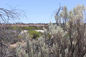
The name Kalgoorlie is thought to derive from the Aboriginal word ‘karlurlah’ the name of a common plant in the area. The entire region is rich in geological history. My son and I like investigating more recent times. We’ve visited ghost towns, old mines, natural pools and lakes, including Lake Ballard featuring Antony Gormley’s amazing bronze sculptures, wood lines which supplied the timber for steam engines and water distillation, abandoned pubs (hotels) and cemeteries. I’ve seen wild flowers I’ve never seen before and wandering camels, emus and a horse which lives at the hotel in Kookynie and visits everyone in the (very small) town every morning for breakfast.
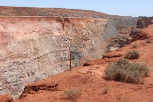
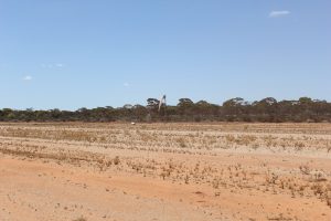
This time we headed out east of Kalgoorlie in the same direction as the Trans Australian Railway. Stopped at the abandoned open pit Imperial Gold Mine before heading on to Karonie. Other minerals mined in the eastern Goldfields include nickel, cobalt, silver, lithium, zinc, tantalum and most of the rare earths. Potassium sulphate is harvested from dry salt lakes.
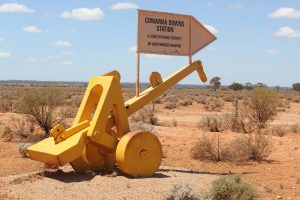
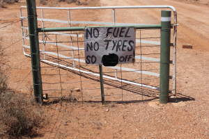
Passed the entrance to a station and admired the use of old machinery for signage. They had another more pointed message on the gate.
We were a long way from anywhere and it pays to be well prepared for anything that might happen.
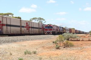
We were parallel with the Trans Australian Railway line and slowed so we’d be sitting at the crossing in time to watch the freight train next to us on the track. It was very long! It was slowing down and finally stopped. The train, from Perth, was waiting for another train, heading towards Perth, to pass on a stretch of double lines. Most of the Trans line is just a single track. We sat there for 35 minutes. The diesel engine of the train was turned off while they waited and all we could hear was the slight hum of some of the freezer containers, many of them stacked two high.
The second, much smaller train arrived and passed, the first train started up and slowly moved on and we were able to cross the line and head for the Karonie Covered Dam. Passed these granite outcrops which seem to have been mined recently. Maybe for road base?
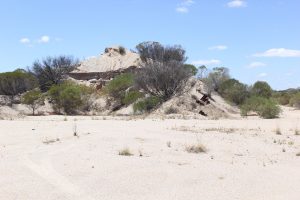
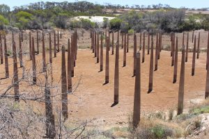
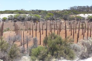
Arrived at the Karonie ( corruption of the Aboriginal word Cardonia, meaning rocks) Dam. It has long since lost its cover designed to limit water evaporation. The pillars holding the roof are reinforced concrete and are now collapsing. Built in 1913-1918 when the Trans Australian Railway was being built, the dam provided water for the steam locomotives.
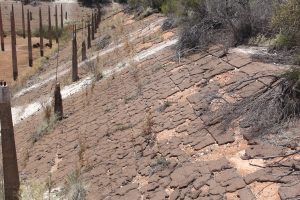
The surrounding rocks were terraced to direct the water into the dam. The terracing is similar in style to the construction work done at the Northam Army camp and was probably also done by Italian POW’s.
The line across the rocks in the distance is terracing intended to direct the water into the dam.
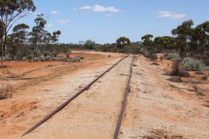
Old train tracks used when the Trans Australia line was built.
In 1919, during the Spanish Flu epidemic, Karonie was also the site of the Karonie Quarantine Station.
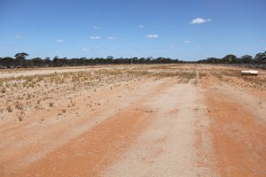
On the way back we stopped at a public bush air strip, intended for local and Royal Flying Doctor planes. The motto of the RFDS is ‘The furtherest corner, the finest care’. The service provides emergency and primary health care to rural and remote areas of Australia. Begun 1928 by John Flynn, the RFDS is recognised as one of the largest and most comprehensive global aeromedical services in the world. In this area they service both mining and rural communities as well as the local towns.
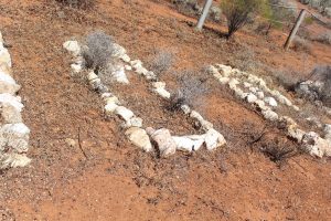
Next stop was the Bulong Pioneer Cemetery. I’d driven passed this little fenced in area several times before but this time we stopped. This cemetery was in use between 1894-1898. There are 10 unmarked graves and a list of names of the interred on site. Later research revealed the most common cause of death was fever. An infant was simply named, one man’s demise was the result of a ‘brawl in a bar’ and another, a circus employee ‘died after driving a waggon (sic) into a tree.’
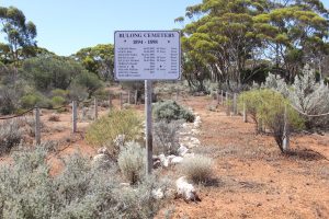
There is a second, much bigger Bulong Cemetery. The town was originally called IOU but that was changed in 1895 to Bulong, the Indigenous name for the area.
I’d like to thank the Eastern Goldfields Historical Society for their assistance sourcing information about the Karonie Covered Dam. www.kalgoorliehistory.org.au
Blogs about previous trips to Kalgoorlie can be found here.
A Week in Kalgoorlie (Part One)
A Week In Kalgoorlie (Part Two)
What a fascinating post, thank you so much, I really enjoyed reading it.
Hello!
Thankyou for your kind comments! I love to go exploring and Kalgoorlie is an old settlement with a rich Indigenous and gold rush history.
Our son is a geophysicist and explains the geological history of the area to me so it’s very interesting.
Deborah